

A cloth escape map could cover several countries and fold down into a small pocket. Its military value came from the combination of the map image, a durable substrate and a lasting print. British MI9 maps, American AAF Cloth Charts and Australian RAAF silk maps met this requirement through different materials and printing methods. The later Evasion Chart adds information about survival and evasion in the mapped area.
Silk and rayon: a map that could remain with its wearer
Early British MI9 maps were printed on silk. The thin fabric folded tightly, could be carried unobtrusively and remained usable after getting wet. Paper needs additional protection against this treatment; on a cloth map, the print itself had to suit the substrate and remain legible after getting wet. Reduced rustling compared with paper also helped when handling it at night.
One specific early example is the British-made Waddington S2/S3 map from around 1941, used in Greece by Sergeant Richard Sydney Turner of the Australian Army Service Corps. The black print on silk shows Greece and Crete on one face and a wider area including Italy, the Balkans and the Aegean on the other. A conversion key for kilometres and English miles appears on the overview face. Front and back thus supplied different geographical contexts without requiring a second piece of material.
From about 1942, silk shortages led to the use of treated rayon fabrics. These included viscose, cuprammonium rayon and acetate. Treatment prepared the surface for printing and could initially give it a stiffer feel. The MI9 K3/H2 map made around 1942 and associated with RAAF airman Norman Frederick Skinner used black, red and green printing on rayon. K3 covers North Africa at 1:6,000,000; H2 covers Spain, Sardinia and the North African coast at 1:3,000,000. An equal length on the North Africa face therefore represents twice the distance. Turning the map over also requires changing the scale used to read it.
1943 and 1944: paired faces, frontier insets and terrain
The British European series of 1943 expanded the colour map image and used identifiers such as 43/C and 43/D. A surviving C/D sheet measures 71 × 73 centimetres. Its two main maps cover the Netherlands, Belgium, north-eastern France and parts of Germany on one face, and south-eastern France, south-western Germany and Switzerland on the other. An additional map enlarges the Belgian-German frontier area. This combined broad geographical coverage with a more detailed view of a particular border region on the same substrate.
Height tints and spot heights, roads with distances, railways and mountain passes conveyed more than the locations of towns. Present and former frontiers and a demarcation line helped distinguish politically and militarily defined areas in that edition. The key explained which line symbols represented boundaries and which represented roads or other routes; at a glance, these could be confused. Folding had to keep the identifier, key and map area needed for the next stage accessible.
The South-East Asian sheets 44/C and 44/D of 1944 use a different arrangement. A 62 × 96 centimetre cloth sheet carries parts of Burma, Siam and French Indo-China on one face and extreme southern Burma and southern Siam on the other. Both use 1:1,000,000. Contours, height tints and spot heights supplement roads, tracks, waterways and boundaries. A small index map shows the positions of adjacent territories. It helps the user determine whether the required continuation is on the reverse or needs another sheet.
American and Australian maps in one issued kit
American manufacture did not mean exclusively American use. The AAF Cloth Chart C-43/C-44 made by the US Army Map Service around 1944 combines Mindanao and North Borneo on opposite faces of a white acetate sheet; both maps are at 1:1,000,000. One such example was part of the escape kit actually issued to navigator Robert Forbes in Catalina A24-97 of 42 Squadron RAAF. He carried it on the operation in the Manila area on 14 December 1944.
The same kit contained an Australian silk map of Halmahera and western New Guinea from around 1944. It is printed on one face only and gives its scale as six inches to 90 statute miles. Supplies from different countries could thus come together in an individual's issue. The user had to work with the areas shown and the distance statement on each map.
Manufacturing also differed. On 1 September 1944, rolls of silk scarf material were being fed through a rotary press at the Argus newspaper in Melbourne to make maps for Australian aircrews in the South-West Pacific. Such cloth maps were normally printed as pre-cut sheets on lithographic presses. This Australian process printed onto a continuous fabric web. A RAAF silk map therefore differed technically from an American print on acetate, even when both were carried for the same possible area of isolation.
USAAF chart No. 135: mapping and an appeal for help
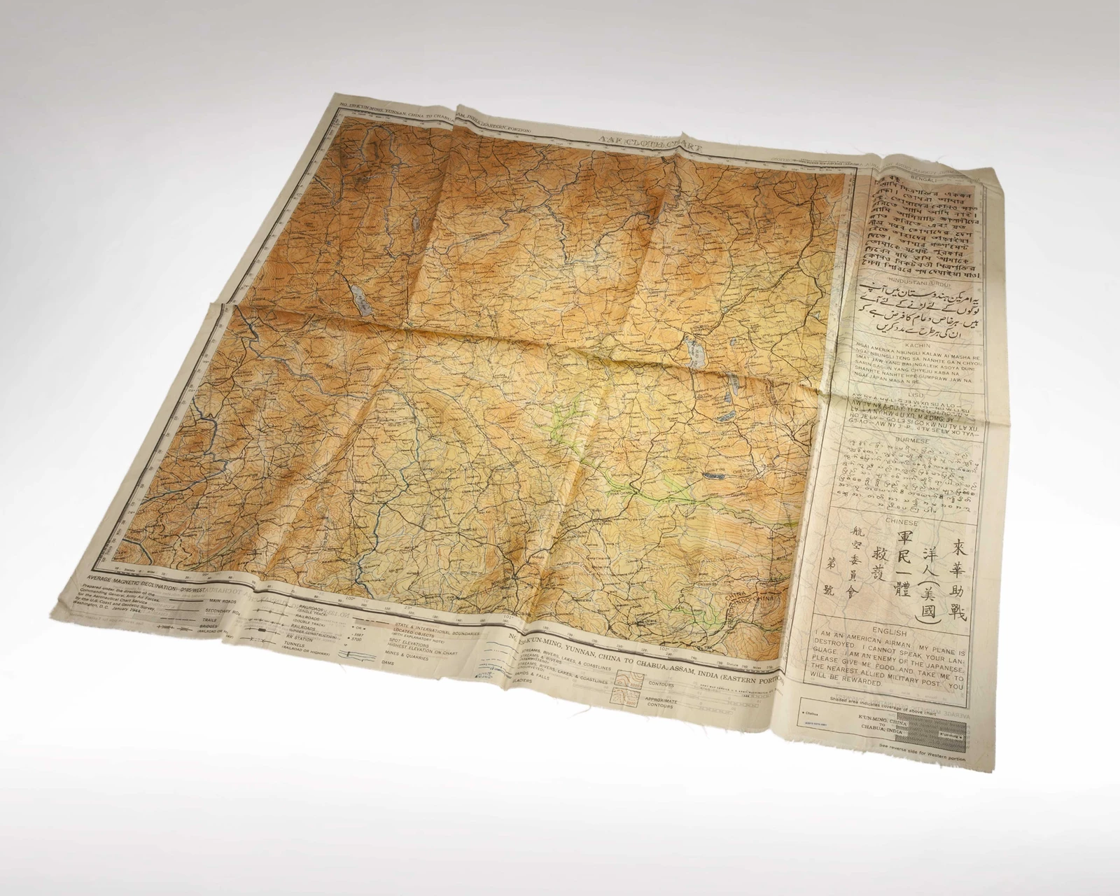
The cloth chart No. 135 in the CIA Museum shows Kunming in Yunnan to Chabua in Assam, in this case the eastern portion. The 86 × 75 centimetre object carries a January 1944 printing statement naming the US Army Map Service, Aeronautical Chart Service and Coast and Geodetic Survey. Waterproof dyes on its silk substrate prevented the colours from running when this chart got wet. Along the lower margin are symbols for roads, trails, bridges, railways and other features, together with a magnetic declination statement. A small index identifies the area covered and directs the reader to the reverse for the western portion.
A broad strip at the side carries an appeal for help in several languages. It identifies the bearer as an American airman whose aircraft has been destroyed and asks for food and assistance reaching the nearest Allied military post. It promises a reward. This performs a function related to that of a Blood Chit, but places it directly beside the map image. The chart could remain concealed during personal navigation; showing the message required the wearer to reveal their allegiance. Whether to make that contact depended on the behaviour of the people encountered and the local circumstances. The prepared text could bridge a language barrier.
Evasion Charts: from woven fabric to a printed fibre web
American Tyvek Evasion Charts carry their navigation mapping and marginal survival and evasion information on the same substrate. Versions are available at 1:250,000. Marginal panels can carry local information about navigation, environmental hazards, protection and supplies. Placing it on the same substrate keeps the information with its geographical context. This is particularly useful when separate documents have been lost and an electronic device can no longer be used.
Tyvek consists of very fine, continuous fibres of high-density polyethylene. They are laid as a randomly arranged web and bonded by heat and pressure. Unlike silk or rayon, the sheet is therefore formed without woven warp and weft threads. The material absorbs little water and combines low mass with high strength. The strong, durable and waterproof substrate supports repeated carrying and use of an EVC in wet conditions.
Printing requires the surface, ink and process to work together. Some methods need a suitable coating for ink to adhere to the relatively non-absorbent material. Ordinary laser printers often use fusing temperatures above Tyvek's melting point of 135 °C. NGA provides its Print on Demand maps, including EVCs, as colour-managed print files for different output devices. Printing such a file on ordinary paper reproduces the map image; producing the physical waterproof chart also requires a suitable substrate and compatible printing.
Preserving legibility and complete information
Before carrying the chart, both faces are opened and the sheet identifier, area, edition, scale and marginal panels are located. It is then folded so that the required section can be exposed without spreading out the whole sheet each time. This protects the print and limits the exposed area. Cutting off a map margin saves space but may remove the key, scale or index needed to find the continuation. A compact, complete fold serves the user better than a smaller fragment without the information needed to read it.
With a damaged map, the first task is to establish which information has actually been lost. A hole in an empty margin has a different consequence from abrasion across a river crossing or road junction. Cutting and closely spaced stitching can further weaken a Tyvek sheet: needle holes do not close in the bonded fibre web as they can when woven threads move. Diverting the map to use as spare material can destroy both printed faces and the geographical information they hold at the same time.
Every map remains tied to the date of its survey and edition. Roads, bridges and boundaries may have changed; on historical maps, the declination statement also belongs to that edition. When a current map and a device position are used together, geodetic reference and coordinate format must agree. The relationship is explained in the entry on MGRS and geodetic reference.